Fluids undergo continuous deformation, i.e. fluids always keep flowing. To define fluid, it is a substance that does not possess a definite shape and easily yields to external pressure. Fluid is any liquid or gas or any material that is unable to withstand a shearing or tangential force, when at rest. When the said forces are applied to the fluid, it goes through a continuous change in shape. Fluids are substances with zero shear modulus, i.e they cannot resist the shear force applied to them.
In our day-to-today life, we would have heard the dehydrated patient advised to consume more fluids to compensate for the water loss. Fluids help in the digestion of food, hence we need to take more fluids.
Classification of Fluids
Fluids are classified into four types depending on its flow, they are:Steady or unsteady
Compressible or incompressible
Viscous or non-viscous
Rotational or irrotational
Steady fluid: It is the fluid whose density remains constant at each and every point while flowing.
Unsteady fluid: It is the fluid whose velocity differs between any two points while flowing.
Compressible fluid and incompressible fluids: These are classified based on the mach number. The incompressible fluid has mach number<0.3 and the compressible fluid has mach number between 0.3 and 1.
Viscous or Non-viscous
Fluids with more thickness or viscosity are known as viscous fluids, they are generally very gloppy fluids. Examples: shampoo and motor oil.
Fluids with comparatively less thickness or viscosity are known as non-viscous fluids. These are the fluids with no resistance or negligible resistance to internal friction. Non-viscous fluids flow without any loss of kinetic energy.
Example: Superfluid liquid helium
Sunday, August 09, 2020
SOIL FORMATION
by Mr.Bright Brabin Winsley J
Soils differ from one part of the world to another, even from one part of a backyard to another. They differ because of where and how they formed. Climate, organisms, relief (landscape), parent material and time are five major factors of interaction creating different types of soils.
Climate: Temperature and moisture influence the speed of chemical reactions, which in turn help control how fast rocks weather and dead organisms decompose. Soils develop faster in warm, moist climates and slowest in cold or arid ones.
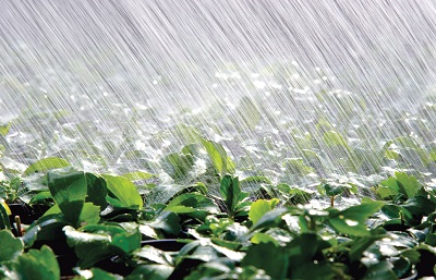
Rainfall is one of the most important climate factors in soil formation.
Organisms: Plants root, animals burrow, and bacteria eat – these and other organisms speed up the breakdown of large soil particles into smaller ones. For instance, roots produce carbon dioxide that mixes with water and forms an acid that wears away rock.
Termites can generate mounds in the soil that are three stories tall!!!
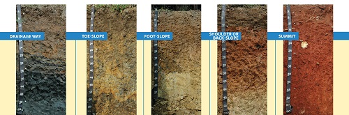
Relief (landscape): The shape of the land and the direction it faces make a difference in how much sunlight the soils gets and how much water it keeps. Deeper soils form at the bottom of a hill because gravity and water move soil particles down the slope.
Soils are different depending on the location in the slope that they are located.
Parent material: Every soil “inherits” traits from the parent material from which it formed. For example, soils that form from limestone are rich in calcium and soils that form from materials at the bottom of lakes are high in clay. Every soil formed from parent material deposited at the Earth's surface. The material could have been bedrock that weathered in place or smaller materials carried by flooding rivers, moving glaciers, or blowing winds. Parent material is changed through biological, chemical and environmental processes, such as weathering and erosion.
These are soils forming in real time from the side of the volcano. They form into rock first, then weather into fertile soil.
Time: All of these factors work together over time. Older soils differ from younger soils because they have had longer to develop. As soil ages, it starts to look different from its parent material. That is because soil is dynamic. Its components—minerals, water, air, organic matter, and organisms—constantly change. Components are added and lost. Some move from place to place within the soil. And some components are totally changed, or transformed.
Monday, August 03, 2020
Smart Building by Abishek G L
Buildings of the future are designed to make human lives easier with the help of complex, smart technology.
Often described as smart buildings or intelligent buildings, buildings of the future are any structures that use integrated processes, smart engineering or creative design to self-regulate the building’s environment and operations.
A human-centred approach to design is at the core of buildings of the future. From the moment people step inside until the moment they leave, a building of the future will have the capability to determine the percentage of the workforce inside the building at any given time and automatically adjust the settings of its facilities according to their feedback and needs – from WiFi connections, lighting, electricity, heat, ventilation and air conditioning, buildings of the future place people at the centre.
Although they are often described as intelligent or smart, buildings of the future are not simply about the use of integrated technology to create reactive environments – they are about people, and how people will use these structures now and in the future.
Wednesday, March 11, 2020
TOTAL
STATION
A total station is an optical instrument
commonly used in construction, surveying and civil engineering. It is useful
for measuring horizontal angles, vertical angles and distance — it does this by
analyzing the slope between itself and a specific point. A high-quality total
station camera combines surveying, imaging and high-speed 3D scanning into one
precise and reliable instrument. It blends the latest field technologies with
advanced technical features to create a tool that is trusty and dependable in demanding
field situations while producing accurate results for analysis and engineering.
·Total stations often contain a
few different components:
·Electronic transit theodolite
·Electronic distance meter (EDM)
·Microprocessor
·Electronic data collector and storage
system
·Operators often use total
stations with additional equipment as well, including tripods, tribrachs,
reflector poles and prisms.
Using total stations for measurements
provides several unique advantages:
Accuracy:
How accurate is a total station? Total stations are highly accurate — to a
fraction of an arc second as well as measure distances to hundredths of a foot
over thousands of feet.
Ease of use:
Total stations are easy and intuitive to use. They can take simultaneous
distance and horizontal measurements, and they make it easy to calculate
coordinates. So, operators can spend more of their time and energy on critical
engineering and analytical problems that demand their attention.
Speed: Total
stations collect information quickly, so operators can get in and out of the
field efficiently.
Convenience:
Total stations offer quick and convenient setup. With a total station, an
operator can take multiple surveys from one location.
Effortless CAD interface: It’s easy to download survey data to a computer-assisted drawing
(CAD) program to avoid time-consuming data manipulation.
What Are the Types and Features of Total
Stations?
How many types of total stations are there?
There are a few different types of total stations, each with unique features for
use in various applications.
Mechanical total stations: Mechanical total stations are reliable and accurate, and they make
surveying quick and easy. They do not offer remote control operation or
automated features, however, and operation typically requires two people.
Robotic total stations: These total stations allow for more technological convenience. They
offer extended remote control abilities, they need only one operator, and they
allow for increased safety in challenging terrain because of their unique
ability to operate at a distance.
Prism total stations: Both mechanical and robotic total stations come in prism models.
Prism models are more traditional than reflector-less models, and they are
still more commonly used. They use prisms to reflect infrared waves and then
determine angles and distance by measuring the prism’s location.
Reflector-less total stations: Both mechanical and robotic total stations come in reflector-less
versions, as well. These newer models of total stations are useful for taking
measurements in challenging circumstances. They can work in difficult terrain
or in places you can’t reach on foot, and they don’t require the use of a
prism.
So, what are the features of a total
station? Total stations also offer many different features to enhance their
usefulness in different applications, such as:
·Superior EDM for high accuracy
and long-range prism measurements.
·High-accuracy scanning and
scanning range technology.
·High-resolution site imagery
technology.
·Imaging solutions like video
robotic control and photogrammetric measurements.
·Integrated surveying with
global navigation satellite system (GNSS) receivers.
·Seamless field-to-office
integration with software for data processing, analysis and use.
·Optional solutions for locating
lost or stolen equipment.
How Are Total Stations Used?
How is a total station camera used on the
job site? Surveyors and civil engineers can use total stations to assess
topography, record existing natural features, or plan for buildings, roads and
land boundaries. These impressive and accurate instruments are also useful in
mining, meteorology, archaeological digs, forensic investigations and building
information modeling (BIM).
Total stations are particularly useful for
performing functions like these:
·Topographic surveys
·Land and title surveys
·Roadway and corridor surveys
·Design surveys
·Infrastructure surveys
·Volumetric surveys to measure
stockpile volumes
·Power line inspections
·Utility design surveys
·Crash scene investigations
·Crime scene investigations
·Mine and quarry surveys
·Tank calibration or inspection
\
Tuesday, February 04, 2020
Sway
and non-sway in frames
A frame is
considered to be non-sway (braced) if it is sufficiently braced by lateral
bracing elements like structural walls. On the other hand, frames that provide
lateral resistance only through columns are considered to be sway frames
(unbraced). ACI 318-19 can be used as a reference to distinguish between sway
and non-sway frames. It should be noted that purely sway and non-sway frames
rarely exist in practice, hence, the design should be prepared based on the
requirements. For instance, the designer should decide in advance if the
bracing provided by shear walls, elevators, utility shafts, stairwells, or
other elements would be sufficient to limit the structure against significant
sway effects. It is possible that a particular storey in a structure could be
sway while another is non-sway.
Sunday, January 05, 2020
CANAL IRRIGATION
A canal is an artificial channel that is constructed to carry water to the fields to perform irrigation. The water is taken either from the river, tank or reservoirs. The canals can be constructed either by means of concrete, stone, brick or any sort of flexible membrane which solves the durability issues like seepage and erosion. The distribution system in a canal irrigation system, canal alignment, curves and certain features of canal irrigation are briefly explained in this article.
Distribution System for Canal Irrigation System
The figure-1 below shows the general layout of a canal distribution system depicting the different networks of canals constituting a canal irrigation system. Whatever be the irrigation scheme i.e direct irrigation using weir or a barrage and storage irrigation scheme like dams or reservoir, both demand a network of irrigation canals of various sizes and capacities. Hence the canal system comprises of:
Main Canal
Branch Canal
Distributaries or major distributaries
Minors or minor distributaries
Watercourses
Canal Alignment
The
canal alignment is selected based on the following considerations:
Canal
alignment must be chosen such that the maximum area is served with the
least length. It also must minimize the use of cross-drainage works.
If
the length of the canal is short, there is less head loss, seepage loss,
and evaporation loss. This also brings additional areas for irrigation.
Following
a straight alignment helps to reduce the loss.
Always
a canal alignment with less cross-drainage work must be chosen.
The
canal must not pass through forest, town, village or costly areas reducing
the chance of giving heavy compensation.
Among
different canals, ridge canals help to irrigate either side of the canal.
It
must help reduce heavy cutting and filling i.e costly embankment
construction must be avoided.
It
is recommended to attain a balance in depth of cutting and depth of
filling.
The
selection of alignment over brackish, rocky or cracked strata must be avoided.
Curves in Canals
It is
always recommended to align the canals without curves. Curves result in
disturbance of flow. This scours the outer side of the canals and results in
silting in the inner curves.In order to avoid, scouring in the concave side, it
is required to provided pitching. The canal curves must be more gentle and
posses more radius in order to take large discharges.
Advantages of Canal Irrigation
The
main advantages of canal irrigation are:
Development
of un-irrigated wasteland.
Dangerous
droughts can be avoided that expedite economic development.
The
water requirement of crops during fluctuation in rainfall intensity can be
met by having a proper irrigation system.
Compared
to conventional watering, higher productivity per hectare land is obtained
due to canals.
The
canals constructed are permanent that require regular maintenance.
Canal
irrigation does not let the water table level go down. It only helps to
increase the water level thus facilitating the digging of wells.
Canals
also serve the purpose of hydroelectricity, drinking water supply, fishery
development, and navigation.
Disadvantages of Canal Irrigation
The
major disadvantages of canal irrigation are:
Any
imbalance in the water distribution process results in a scarcity of water
in some areas and water clogging in other areas. This hence makes the soil
unproductive due to the movement of harmful underground salts and alkalies
to the surface level.
Water
present stationary in the canal results in the growth of worms,
mosquitoes, and insects.
Improper
maintenance results in the collection of sediments in the canals that in
turn affects the capacity of the canal.
Canal
construction demands economic investment and time. Hence, this is not a
solution for all irrigation.
A floating foundation is a type of foundation constructed by excavating the soil in such a way that the weight of the structure built on the soil is nearly equal to the total weight of the soil excavated from the ground including the weight of water in the soil before the construction of the structure. The floating foundation is also called a balancing raft and causes zero settlement to the structure.