Fig. 1: Direction of Inertia Forces
Fig. 3: Lateral Force Resisting System in a House

Fig. 1: Direction of Inertia Forces
Fig. 3: Lateral Force Resisting System in a House

The term solid waste management mainly refers to the complete process of collecting, treating and disposing of solid wastes.
In the waste management process, the wastes are collected from different sources and are disposed of. This process includes collection, transportation, treatment, analysis and disposal. It needs to be monitored so that strict regulations and guidelines are followed.
The process of waste handling and disposal varies in different countries. In India, the processes differ according to the source of solid waste. They can be classified as:
Municipal solid waste can further be divided into biodegradable, recyclable and hazardous domestic wastes. The biodegradable waste includes rotten food, vegetable peel and mostly wet kitchen waste. Recyclable waste includes plastic and hazardous wastes include, bulb, batteries, etc.
The industry generated like chemical factories, medical waste from hospitals are considered as Hazardous Solid Waste and needs special settings to dispose of them.
In any region, solid waste management is very important for the safe disposal of wastes and to reduce environmental pollution and avoid any health hazards that it may cause.
Landfills are the most common method of disposing of solid wastes. Modern-day landfills are designed by taking care of various environmental factors and types of wastes, so as to minimize pollution and health risks.


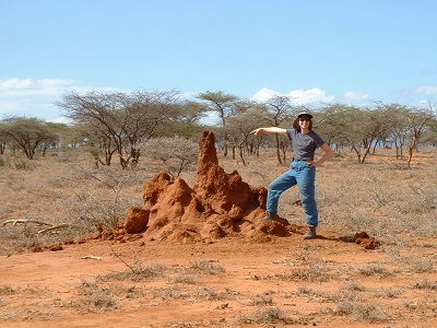
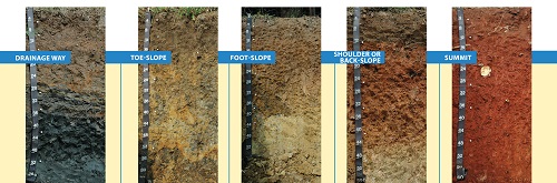
Soils differ from one part of the world to another, even from one part of a backyard to another. They differ because of where and how they formed. Climate, organisms, relief (landscape), parent material and time are five major factors of interaction creating different types of soils.
Climate: Temperature and moisture influence the speed of chemical reactions, which in turn help control how fast rocks weather and dead organisms decompose. Soils develop faster in warm, moist climates and slowest in cold or arid ones.

Organisms: Plants root, animals burrow, and bacteria eat – these and other organisms speed up the breakdown of large soil particles into smaller ones. For instance, roots produce carbon dioxide that mixes with water and forms an acid that wears away rock.

Relief (landscape): The shape of the land and the direction it faces make a difference in how much sunlight the soils gets and how much water it keeps. Deeper soils form at the bottom of a hill because gravity and water move soil particles down the slope.

Parent material: Every soil “inherits” traits from the parent material from which it formed. For example, soils that form from limestone are rich in calcium and soils that form from materials at the bottom of lakes are high in clay. Every soil formed from parent material deposited at the Earth's surface. The material could have been bedrock that weathered in place or smaller materials carried by flooding rivers, moving glaciers, or blowing winds. Parent material is changed through biological, chemical and environmental processes, such as weathering and erosion.

Time: All of these factors work together over time. Older soils differ from younger soils because they have had longer to develop. As soil ages, it starts to look different from its parent material. That is because soil is dynamic. Its components—minerals, water, air, organic matter, and organisms—constantly change. Components are added and lost. Some move from place to place within the soil. And some components are totally changed, or transformed.
TOTAL
STATION
A total station is an optical instrument
commonly used in construction, surveying and civil engineering. It is useful
for measuring horizontal angles, vertical angles and distance — it does this by
analyzing the slope between itself and a specific point. A high-quality total
station camera combines surveying, imaging and high-speed 3D scanning into one
precise and reliable instrument. It blends the latest field technologies with
advanced technical features to create a tool that is trusty and dependable in demanding
field situations while producing accurate results for analysis and engineering.
·
Total stations often contain a
few different components:
·
Electronic transit theodolite
·
Electronic distance meter (EDM)
·
Microprocessor
·
Electronic data collector and storage
system
·
Operators often use total
stations with additional equipment as well, including tripods, tribrachs,
reflector poles and prisms.
Using total stations for measurements
provides several unique advantages:
Accuracy:
How accurate is a total station? Total stations are highly accurate — to a
fraction of an arc second as well as measure distances to hundredths of a foot
over thousands of feet.
Ease of use:
Total stations are easy and intuitive to use. They can take simultaneous
distance and horizontal measurements, and they make it easy to calculate
coordinates. So, operators can spend more of their time and energy on critical
engineering and analytical problems that demand their attention.
Speed: Total
stations collect information quickly, so operators can get in and out of the
field efficiently.
Convenience:
Total stations offer quick and convenient setup. With a total station, an
operator can take multiple surveys from one location.
Effortless CAD interface: It’s easy to download survey data to a computer-assisted drawing
(CAD) program to avoid time-consuming data manipulation.
What Are the Types and Features of Total
Stations?
How many types of total stations are there?
There are a few different types of total stations, each with unique features for
use in various applications.
Mechanical total stations: Mechanical total stations are reliable and accurate, and they make
surveying quick and easy. They do not offer remote control operation or
automated features, however, and operation typically requires two people.
Robotic total stations: These total stations allow for more technological convenience. They
offer extended remote control abilities, they need only one operator, and they
allow for increased safety in challenging terrain because of their unique
ability to operate at a distance.
Prism total stations: Both mechanical and robotic total stations come in prism models.
Prism models are more traditional than reflector-less models, and they are
still more commonly used. They use prisms to reflect infrared waves and then
determine angles and distance by measuring the prism’s location.
Reflector-less total stations: Both mechanical and robotic total stations come in reflector-less
versions, as well. These newer models of total stations are useful for taking
measurements in challenging circumstances. They can work in difficult terrain
or in places you can’t reach on foot, and they don’t require the use of a
prism.
So, what are the features of a total
station? Total stations also offer many different features to enhance their
usefulness in different applications, such as:
·
Superior EDM for high accuracy
and long-range prism measurements.
·
High-accuracy scanning and
scanning range technology.
·
High-resolution site imagery
technology.
·
Imaging solutions like video
robotic control and photogrammetric measurements.
·
Integrated surveying with
global navigation satellite system (GNSS) receivers.
·
Seamless field-to-office
integration with software for data processing, analysis and use.
·
Optional solutions for locating
lost or stolen equipment.
How Are Total Stations Used?
How is a total station camera used on the
job site? Surveyors and civil engineers can use total stations to assess
topography, record existing natural features, or plan for buildings, roads and
land boundaries. These impressive and accurate instruments are also useful in
mining, meteorology, archaeological digs, forensic investigations and building
information modeling (BIM).
Total stations are particularly useful for
performing functions like these:
·
Topographic surveys
·
Land and title surveys
·
Roadway and corridor surveys
·
Design surveys
·
Infrastructure surveys
·
Volumetric surveys to measure
stockpile volumes
·
Power line inspections
·
Utility design surveys
·
Crash scene investigations
·
Crime scene investigations
·
Mine and quarry surveys
·
Tank calibration or inspection
\
pipe appurtenances Various pipe appurtenances or fixtures are required to carry out inspections, tests, and cleaning and repairing works on ...